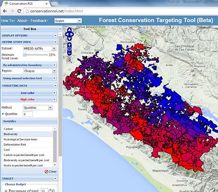
The Forest Conservation Targeting Tool maps areas that will have the highest (red) to lowest (blue) return on conservation investment, as defined by the user’s particular budget and goals.
An Interview with Allen Blackman
Researchers at RFF are developing a free, Web-based interactive decision tool to help policymakers in Mexico, Central America, and the Dominican Republic decide where to invest scarce forest conservation resources. The tool uses rich spatial data on deforestation risk, forest ecosystem services, and the cost of conservation to map trade-offs in conservation investments.
During the past two years, a prototype has been used by The Nature Conservancy to help target conservation investments for the US Agency for International Development’s $29 million program, Mexico Reducing Emissions from Deforestation and Degradation (MREDD). RFF Thomas Klutznick Senior Fellow and project director Allen Blackman recently talked with Resources about how the tool empowers conservation decisionmakers.
RESOURCES: What was the impetus for developing the Forest Conservation Targeting Tool?
ALLEN BLACKMAN: Deforestation and degradation continue to be severe problems in developing countries. They cause all kinds of local and global environmental problems, from soil erosion and flooding to biodiversity loss and climate change. But resources available to address those problems are scarce. That means it is critically important that the resources we devote to forest conservation have the biggest bang for the buck possible.
Juha Siikamäki [RFF associate research director and senior fellow] and I conceived of the Forest Conservation Targeting Tool to do that. The goal is to help decisionmakers choose locations where conservation has the greatest payoff. Building the tool has been a team effort, and I think Juha and I have put together a really good one. RFF Research Assistant Len Goff is responsible for programming the model, and it looks good and works well because of him. Jessica Chu is our geographical information systems expert. We’ve just hired a post-doc named Joe Maher who will play a big role over the next couple of years. And Matt Hansen and Peter Potopov at the University of Maryland are creating our forest loss data using satellite images.
The targeting tool is actually one of two forest conservation decision tools we’re developing as part of a larger project funded by the National Aeronautics and Space Administration’s SERVIR program and the Moore Foundation. While the targeting tool can be used to plan future conservation investment, the other tool is for evaluating the effectiveness of specific policies, such as protected areas and payments for ecosystems, that already are in use.
Looking ahead, we hope to combine these two approaches. We want to enable policymakers to get answers to questions such as, “Where are payments for ecosystem services likely to be particularly effective?” and “Where are protected areas likely to work best?”


