Protected lands along the US eastern seaboard could help shield communities from the impacts of climate change—but these coastal ecosystems are at risk and their ability to bolster resilience hinges on federal, state, and local adaptation measures.

Hurricane Matthew struck the East Coast of the United States in early October 2016, bringing extreme winds and heavy rain that inundated coastal areas from Florida to North Carolina. The storm was the strongest hurricane in the Atlantic since 2007 and provided the latest example of how natural lands in coastal areas can help to mitigate the impacts of extreme weather events. News stories in the hurricane’s aftermath pointed out the important function played by sand dunes along the Florida coast. While they were eroded and damaged, they did their job—providing a critical ecosystem service by absorbing the impacts of waves and protecting properties behind them. Reports highlighted the sharp contrast between the scarred but surviving dunes and the marked destruction of manmade structures such as boardwalks and roads.
Yet many natural areas along the coast are still struggling to recover from the damage they sustained from Hurricane Matthew, including parks in South Carolina that, even by the end of 2016, remained closed to visitors. These outcomes highlight a key feature of coastal natural infrastructure: the lands provide important protective services while at the same time, often bearing the brunt of storms.
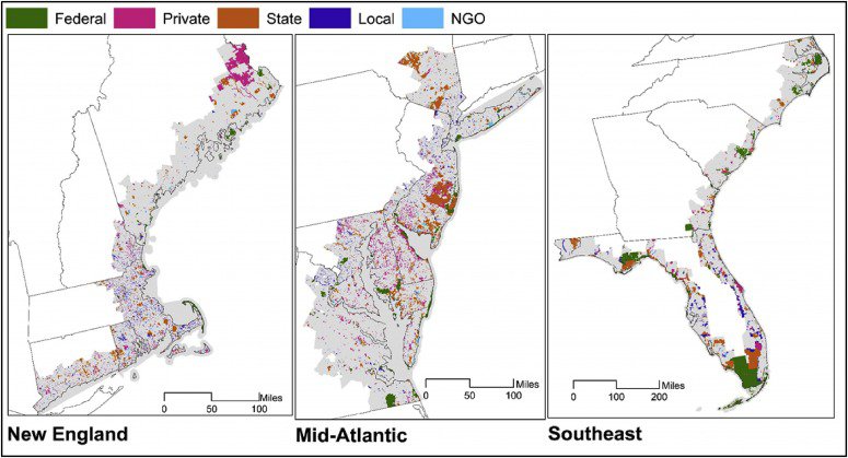
Climate change is expected to increase the frequency of the worst coastal storms and sea-level rise will add to their impacts. The effects of sea-level rise on developed areas, especially cities such as Boston, New York, and Miami, receive a great deal of attention. But natural lands are also susceptible to loss, damage, and change. An increase in sea level has the potential to significantly affect the services provided by natural lands by altering their land cover, increasing erosion and saltwater intrusion, and exposing them to greater risk of flooding or inundation. Governments at the local, state, and federal level, along with land trusts and other nongovernmental organizations, have invested billions of dollars in preserving coastal lands such as parks, wildlife refuges, and other valuable protected areas. In 15 states from Maine to Florida, nearly 15 million acres have been protected (Figure 1)—approximately 20 percent of the land area in shoreline counties (defined by the National Oceanic and Atmospheric Administration [NOAA] as counties directly adjacent to the open ocean or major estuaries).
Figure 1. Protected Land in East Coast Shoreline Counties, by Ownership Category

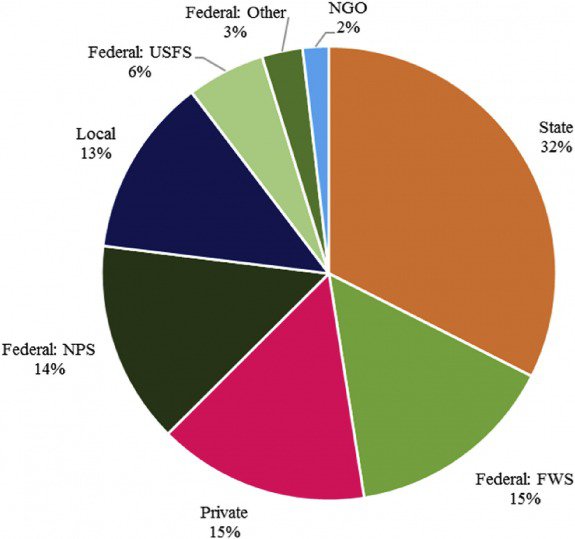
These investments are endangered by potential sea-level rise. In a recent study, we estimated the impacts that sea-level rise will have on the coastal protected lands in shoreline counties of these 15 eastern states; specifically, we determine the types of land cover and associated ecosystem services exposed and assess how well states appear to be poised to handle the effects and adapt. Our results show that one-quarter of protected lands in shoreline counties in these states (approximately 3.8 million acres) would be affected by 3 feet of sea-level rise. Roughly half of this acreage is owned by the federal government, one-quarter by state governments, and the rest by a combination of local governments, nongovernmental organizations, and private owners (Figure 2). We found significant geographic differences, with the biggest impacts in the southeastern states. In North Carolina, over half of protected lands in shoreline counties would be affected by a 3-foot rise, and 42 percent would be affected in South Carolina. By contrast, states in New England will see much smaller effects. Connecticut, Rhode Island, New Hampshire, and Maine each have less than 5 percent of protected shoreline county lands affected; in Massachusetts, that figure is 10 percent.
Figure 2. Percentage of Protected Lands in East Coast Shoreline Counties, by Owner

Threatened Ecosystems
The most vulnerable land types are beaches and dunes (called “unconsolidated shore” in NOAA’s land cover categories) and estuarine wetlands (i.e., salt marshes). Beaches and dunes make up only a small portion of land area in coastal counties, but provide fundamental ecosystem services such as storm protection and erosion control, particularly in the event of extreme storms. They also offer valuable opportunities for tourism and recreation. One study of the impacts of climate change on North Carolina’s coastal resources estimated that 34 percent of the recreational value of trips to beaches in the state would be lost by 2080 due to the impacts of sea-level rise, and that non-local North Carolina residents would spend 48 percent less on beach trips in the same year.
Wetlands also provide essential ecosystem services by attenuating storm surge from hurricanes, storing carbon, filtering nutrients and slowing runoff into estuaries and oceans, and supporting fish nurseries and wildlife habitat. They are also important recreational amenities. A study of Florida’s east coast salt marshes estimated their value for recreational fishing to be $6,470 per acre. Such estimates do not translate directly to estimated losses from sea-level rise, but they illustrate the potentially considerable value of these jeopardized ecosystems and their benefits for environmental and human health and well-being.

State Preparedness
To assess how well-positioned states are to respond to such challenges, we compared the progress states have made in developing climate adaptation plans (using information primarily from the Georgetown Climate Center), which typically include land acquisition, management, and restoration goals—with a close eye on whether those plans addressed protected lands. Most existing plans do not focus on adaptation measures to address sea-level rise in currently protected areas. Of the states in our study, nine had adopted adaptation plans and three had planning under way. The three states with the highest proportions of protected shoreline county lands that will be affected by a 3-foot rise in sea level—North Carolina, South Carolina, and Georgia—are also the only states in our study area that have not begun developing state adaptation plans. Federal agencies manage a large share of these protected lands (69 percent in North Carolina, 65 percent in South Carolina, and 49 percent in Georgia), and planning at the federal level may therefore help streamline adaptation measures for their protected areas. But all three also have substantial state-owned acreage in shoreline counties.
We also looked at states’ overall levels of annual spending on land conservation to evaluate their financial commitments to safeguarding and reinforcing coastal ecosystems (using data from the Trust for Public Land’s Conservation Almanac, which tracks public funds spent on both easements and land acquisitions). Here states differ significantly (Figure 3). Interestingly, Florida, which has the most state-owned lands exposed to sea-level rise in our study area, also spends the most on conservation—more than twice as much annually as New Jersey, which ranks second in both conservation spending and state-owned protected acreage exposed to sea-level rise. From 1998 to 2008, Florida spent between $50 million and $565 million each year, averaging about $246 million annually. The 2001 Florida Forever Act accounts for most of the state’s current conservation spending by issuing $300 million each year in “Florida Forever” bonds. North Carolina rounds out the top three in terms of annual state conservation spending in our study. South Carolina and Georgia are among the states that spend the least; as noted, both have significant proportions of susceptible state-owned lands in our study area.
Figure 3. State Average Annual Conservation Spending and State-Owned Protected Area Vulnerable to 3-Foot Sea Level Rise.

Options for Building Resilience
Our study shows that ownership of these coastal protected lands varies across states and regions, indicating that agencies across all levels of government should be addressing the risks and planning for adaptation—as well as coordinating among groups to streamline action and across activities in multiple areas. The procurement of new lands adjacent to susceptible protected areas will be an especially important part of any adaptation plan. Because sea-level rise may irreversibly alter the capacity for certain lands to support ecosystems as they currently exist, strategic land acquisitions can enable wetlands, for instance, to migrate further inland and may help preserve these valuable systems. Restoring dunes damaged by storms and building structures to protect coastal areas are among a variety of other options that agencies and land managers should consider.
Effective adaptation policies will account for local factors and be tailored for specific contexts.
Authors
Maryland is a leader in preparing for climate change, especially in its adaptation activities on protected lands. The state’s GreenPrint program, which is used to target lands for protection, has been modified in recent years to identify wetlands that are likely to be submerged by sea-level rise, as well as wetland migration corridors that will facilitate the inward movement of wetlands. In addition, all areas that are candidates for easements and acquisitions through the state’s conservation program, Program Open Space, are individually geospatially evaluated for their adaptation services, including storm surge attenuation, carbon sequestration, coastal ecosystem viability, and recreation. Maryland also requires additional adaptation measures through special easements in areas exposed to sea-level rise, including limits on impervious surfaces and development setbacks. In our view, other states could learn from Maryland and take steps to restore and replace their valuable investments in coastal protected lands by strengthening the resilience and adaptability of these ecosystems in the face of climate change.

Ultimately, decisions about which adaptation measures to undertake with limited resources will likely vary depending on the goals of the landowner or manager and the missions of related agencies. At the federal level, for example, the National Park Service aims to preserve natural and cultural resources so that current and future generations of visitors may enjoy them, whereas the Fish and Wildlife Service is charged with conserving, managing, and restoring lands to preserve natural habitats for fish, birds, and wildlife. Differing drivers also exist at state-level agencies and will likewise influence choices about which adaptation measures to pursue to maximize conservation investments with limited financial resources. Indeed, given the diversity in motivations for conservation, land types, and agency jurisdiction, as well as funding commitments, effective adaptation policies will account for local factors and be tailored for specific contexts.


