Earth Observations, Decisions, and Societal Benefits
Our daily lives are shaped by satellite data. We rely on mapping apps and GPS to find our way around our neighborhoods and around the world. We use satellite-driven weather forecasts to make decisions that range from mundane to critical—from what to wear tomorrow to whether to evacuate during a hurricane. As the amount of data that satellites and aircraft capture about Earth skyrockets—and our capacity to convert these data into useful metrics keeps pace—data-driven decisionmaking is undergoing something of a renaissance. Today, people are applying Earth observations to a wide range of decision contexts, using them to monitor air quality, predict harmful algal blooms and mosquito-borne disease outbreaks, detect changes in crop conditions and the amount of water stored in aquifers, and much more. On an almost daily basis, research and development efforts in academia, government, the private sector, and NGOs are producing new products that help us improve our understanding of Earth.

This revolution has been well publicized and comes as no surprise to many of us. What is less well-documented is the way in which our improved understanding of Earth leads to better societal outcomes. Intuitively, we can see that remote sensing improves our understanding of Earth’s systems, which allows people to make better decisions in the face of uncertainty, and ultimately benefits society. However, what is less clear are the outcomes of decisions that can be influenced by satellite data, and the value to society of outcomes that are improved thanks to such data. For example, we know that the National Weather Service (NWS) uses satellite data to issue weather forecasts and warnings. But how do NWS staff make decisions using these data? How are the outcomes of their decisions different from those people would make if the satellite data were unavailable? Assuming that satellite data improve the accuracy of forecasts and warnings, how can we quantify other potential societal benefits such as better crop yield for farmers who can adjust their on-farm practices thanks to improved forecasts? What about the lives saved from faster and more spatially accurate targeted evacuations ahead of an impending storm?
What is less well-documented is the way in which our improved understanding of Earth leads to better societal outcomes.
It is important to understand in a precise way how satellite data influence decisions because we need this information to be able to quantify the societal benefits that stem from the satellite data. In turn, quantifying the societal benefits of applications of satellite data is important in order to demonstrate return on investment in satellites and associated data production activities, and to shape priorities across potential future investments.
Below, we provide two examples that document the first step in this process: understanding how federal and state agency employees are using satellite data to make decisions in specific contexts. In each example, we focus on (a) how the satellite data improves the information available to decisionmakers, (b) the decisions that are informed by the satellite data, and (c) the outcomes that are influenced by the decisions. These examples illustrate an approach we can use to map out the way in which satellite data affects decisions—what economists would call the “value chain” of satellite information. By growing this body of documented examples, we set the stage for future work to quantify how specific applications of satellite data benefit society.

How Are Earth Observations Linked to Societal Benefits?
The United States Drought Monitor (USDM), produced by the National Drought Mitigation Center, consists of weekly maps that indicate where drought is occurring, its severity, and whether it is a long-term or short-term drought. The experts who produce the USDM take advantage of a wide variety of data sources in assessing weekly drought conditions, and some of these data are derived from satellite systems, such as the Vegetation Drought Response Index, which provides improved understanding of seasonal vegetation conditions related to drought. Experts similarly use data from the Gravity Recovery and Climate Experiment satellite system, which provide estimates of groundwater availability. The USDM informs decisions made within a variety of programs at the US Department of Agriculture and the Internal Revenue Service that are designed to mitigate the economic impacts of drought. The people who benefit from these decisions include agricultural producers, their families, and local communities, who all may experience hardship from drought and, through federal emergency drought assistance programs, receive benefits that offset revenue losses from economic shocks due to lost income and inventory. To the extent that satellite data improve the ability of the federal agencies to determine where and when drought is occurring, drought disaster assistance funds are more likely to be allocated to the communities that need them the most, thus improving the overall efficiency of drought programs.
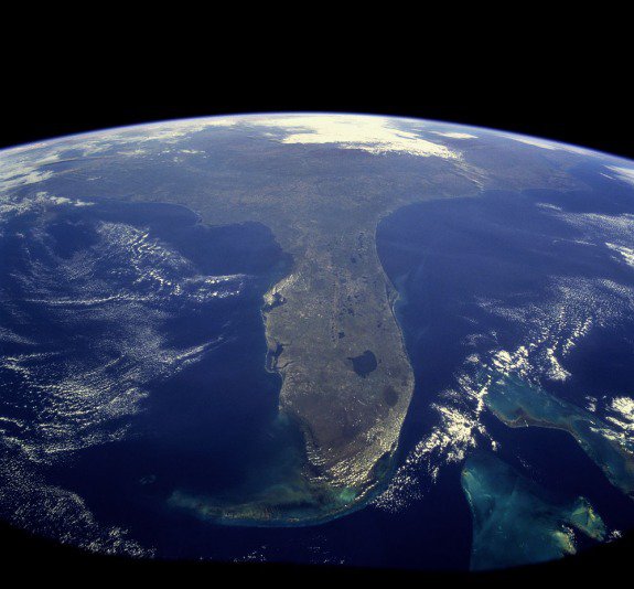
Our second example documents how Florida uses Earth observations to regulate coastal water pollution from nutrients under the Clean Water Act. Historically, water quality data collected from the field were not of sufficient resolution to be used for this purpose and it was impractical to enforce water quality standards using on-site measurements. To address the need for higher-resolution data, scientists from the US Environmental Protection Agency (EPA) and the National Oceanic and Atmospheric Administration (NOAA) applied their expertise in remote sensing technology. Using two satellite sensors, the Sea-Viewing Wide Field-of-View Sensor and the Moderate Resolution Imaging Spectroradiometer, EPA and NOAA scientists developed a tool to establish criteria for coastal nutrient concentrations and monitor compliance with these criteria. It is notable that this monitoring protocol is specified in state law: “achievement of these criteria shall be assessed only by using satellite remote sensing data that are processed in a manner consistent with the derivation of the criteria” (Florida Administrative Code 62-302.532). Moving forward, the use of satellite data should allow Florida to target water quality controls more effectively. The societal benefits associated with improved water quality management include increased profits to the commercial fishing sector, increased waterfront property values, recreational benefits from swimming, boating, and beach visitation, as well as aesthetic value.

False color visualization of the SeaWiFS image reveals concentration of the microscopic plants and other dissolved matters.
Valuing and Communicating the Societal Benefits of Earth Observations
To understand the socioeconomic value of Earth observations in a particular application, we need to perform a three-step process. First, we characterize how that observation improves the information available. Second, we identify the decisions that can be influenced by the improved information. Third, we compare the outcomes we would see in two different cases: a decision made with improved information from Earth observations and a decision made without this improved information. We described this three-step process for valuing information in the two examples above. These examples, together with other applications of satellite data that generate societal value, will be documented in a forthcoming series of use case briefs from the Consortium for the Valuation of Applications Benefits Linked with Earth Science (VALUABLES). The VALUABLES Consortium is a five-year cooperative agreement between Resources for the Future and the National Aeronautics and Space Administration (NASA) working to advance methods to value and communicate the applied benefits linked with Earth observations. In the coming years, the consortium will dig deeper into the value chains introduced here by carrying out case studies that produce quantitative estimates of the value of satellite data in a variety of application areas. Learn more about the VALUABLES consortium or sign up below to receive emails about the use case briefs and other consortium activities.


